














Texas Border Business




Texas Border Business
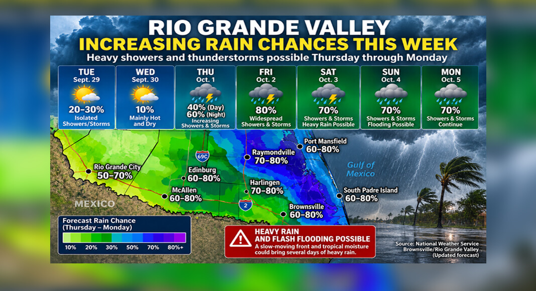
RIO GRANDE VALLEY, Texas — The threat of significant rainfall across the Rio Grande Valley has increased, with the National Weather Service now warning of a multi-day period of heavy rain and potential flash flooding beginning Thursday and continuing into early next week.
The National Weather Service Brownsville/Rio Grande Valley office said confidence is increasing that a significant change in the region’s weather pattern will bring markedly cooler and wetter conditions after several days of above-normal heat.


A slow-moving front interacting with tropical moisture is expected to increase showers and thunderstorms across Deep South Texas by late Thursday. The NWS said heavy rainfall could produce isolated flash flooding Friday and into the weekend, although uncertainty remains over the timing and where the heaviest rain will develop.
The change represents an increase from earlier forecasts that showed lower rain probabilities across much of the Valley.
Around Harlingen, earlier forecasts placed Friday’s rain probability at roughly 60% to 70% and Saturday near 60%. Updated forecasts increased those probabilities to about 80% Friday and 70% Saturday. Rain chances also remain elevated Sunday and Monday, extending the potential wet period into early next week.
Thursday is expected to mark the beginning of the transition. Rain chances around the Harlingen area increase during the day and rise further Thursday night as deeper moisture and the approaching weather system affect the region.
The National Weather Service said the developing pattern could become a multi-day heavy-rain event rather than a brief period of isolated thunderstorms. Its forecast discussion specifically identifies heavy rain and flash flooding as potential hazards from Thursday through early next week.
However, the forecast does not mean flooding will occur throughout the Rio Grande Valley. Rainfall amounts can vary considerably from one community to another, and the NWS said uncertainty remains about where bands of heavier rainfall will develop.
The wetter weather will follow another period of intense heat across Deep South Texas. The NWS said above-normal temperatures are expected through Thursday, with dangerous heat indices potentially reaching 105 to 115 degrees in parts of the region before a cooler, wetter pattern takes hold.
Residents should continue monitoring updated forecasts because rainfall probabilities, timing, and areas at greatest risk could change as the front approaches.
The National Weather Service Brownsville/Rio Grande Valley office advises residents to have multiple ways to receive weather warnings, particularly as the potential for heavy rainfall and localized flash flooding increases heading into the weekend.
Source: National Weather Service Brownsville/Rio Grande Valley.