


Legal claim is one of two regarding Mexico’s territory
Texas Border Business


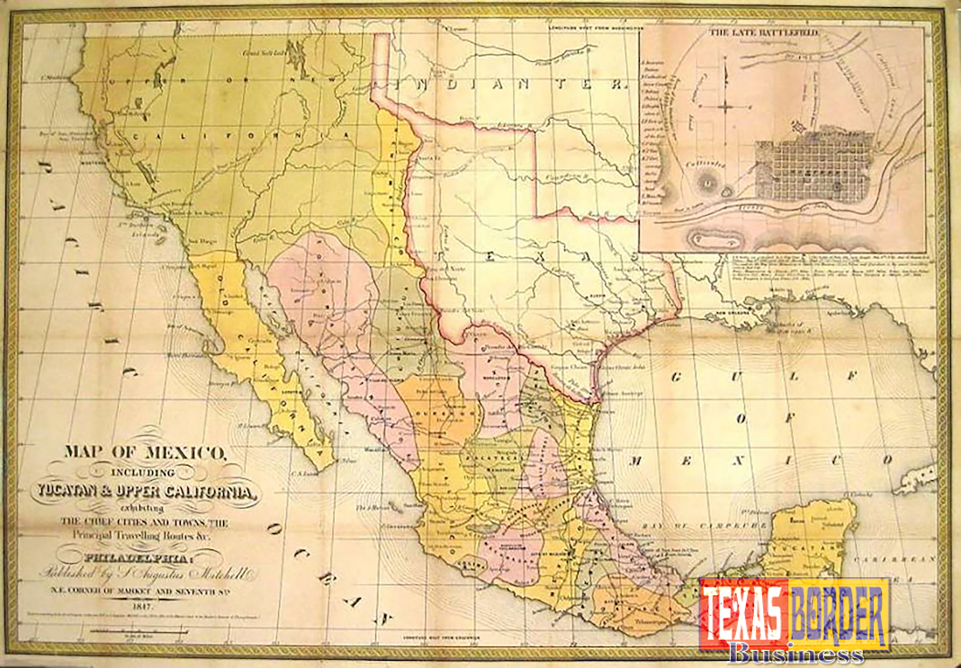
The deterioration in relations between Mexico and the United States has triggered a couple of claims over the countries’ common border, one of which would put into question the ownership of five U.S. states and parts of four others.
A prominent Mexican politician and a lawyer proposed a legal claim that would invalidate the treaty with which Mexico surrendered half its territory to the United States.
Former Mexico City mayor and three-time presidential candidate Cuauhtémoc Cárdenas and lawyer Guillermo Hamdan Castro argue that the 1848 Treaty of Guadalupe Hidalgo fails several tests as to its validity.


The treaty gave the U.S. what is now California, New Mexico, Arizona, Nevada and Utah and parts of Colorado, Wyoming, Kansas and Oklahoma.

Hamdan said during a presentation in Cuernavaca, Morelos, that the most important element is in the accord’s first sentence, which contains an admission that the U.S. army invaded Mexico. Signing an agreement in that context renders it null, he said.
Another legal factor is that the agreement ceding Mexico’s territory was signed under pressure.
Hamdan conceded it would be impossible for Mexico to recover the lost territory should the legal claim be upheld, but suggested instead the U.S. should pay compensation for the use of the land over the last 168 years.
But given that the dollar “has meant nothing since the 1970s,” he observed, payment should be in gold or pesos. No amount was stated.

Cárdenas, a founder of the leftist Democratic Revolution Party, and Hamdan called on Mexicans to join them in a march to Los Pinos, official residence of President Enrique Peña Nieto, to present the proposal.
Hamdan said the president is the only person who can take the claim before the International Court of Justice.
The second claim is that 430 kilometers (267.19 miles) of the border was incorrectly marked, meaning that about 85,000 hectares (210,039.5742 acres) now in Arizona and New Mexico, actually belong to Mexico.

The claim has been made by Senator Patricio Martínez, a former governor of Chihuahua, who discovered the mistake in the 1990s. In the mid-19th century, he said, piles of stones were used to mark the border. But towards the end of the century Mexico found the cairns had been destroyed and parts of the border marked too far south, according to a report by the Financial Times on March 10, 2017.
Martínez’ discovery was based on an engineer’s report. A second study conducted since has confirmed the finding, he said. Now he plans to file a motion in the Senate to have the mistake corrected.
He said the matter was raised by Mexico in a letter to the Secretary of State in 1897, but was subsequently forgotten.
To read the introduction in English/Spanish by attorney Guillermo Hamdan Castro, follow this link.
To read Treaty of Guadalupe Hidalgo By Richard Griswold del Castillo, follow this link.
To read an additional article about Mexican territory, follow this link.