
















Texas Border Business




MEXICO CITY — Hurricane Polo intensified into a Category 5 hurricane Tuesday off Mexico’s Pacific coast, prompting warnings for portions of the southwestern coastline as forecasters cautioned that heavy rainfall could cause life-threatening flooding and mudslides.
At 9 a.m. CST Tuesday, Polo had maximum sustained winds of 165 mph, or 270 km/h, with an estimated minimum central pressure of 920 millibars, according to the National Hurricane Center.
The hurricane’s center was about 205 miles south of Zihuatanejo, Guerrero, and 345 miles south-southeast of Manzanillo, Colima. Polo was moving north at about 2 mph. Hurricane-force winds extended up to 35 miles from the center, while tropical-storm-force winds extended outward up to 90 miles.




The National Hurricane Center forecast Polo’s core to move close to and roughly parallel to southwestern Mexico while remaining offshore. Forecasters said uncertainty remained over how close the hurricane would approach the coast and the extent of resulting wind, rainfall and surf impacts.
Mexico issued a Tropical Storm Warning from Tecpan de Galeana to Punta San Telmo and a Tropical Storm Watch from west of Punta San Telmo to Playa Perula. Tropical-storm conditions were expected within the warning area by early Wednesday and were possible within the watch area by Thursday.
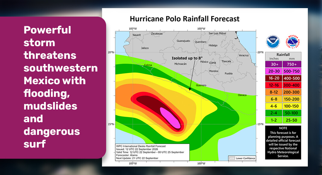
The National Hurricane Center forecast 3 to 6 inches of rainfall across coastal portions of Guerrero and Michoacán through Thursday, with isolated totals approaching 8 inches. Forecasters warned that the rainfall could produce life-threatening flooding and mudslides, particularly in areas of steep terrain.
Coastal portions of Oaxaca, Colima and Jalisco were forecast to receive 2 to 4 inches of rain during the same period.
Swells generated by Polo were also expected to affect portions of southwestern Mexico. The National Hurricane Center warned that the swells could produce life-threatening surf and rip-current conditions along the coast.
Polo strengthened rapidly before reaching Category 5 intensity. The storm had maximum sustained winds of 40 mph early Sunday before becoming a hurricane Monday and continuing to intensify, according to National Hurricane Center data. Forecasters said additional strengthening was possible Tuesday, followed by potential fluctuations in intensity Wednesday. Authorities continued monitoring the hurricane as it approached southwestern Mexico, with additional watches or warnings possible along the coast.