


Texas Border Business

December 30, 2025, marks an important historical anniversary for the United States and Mexico. On this day in 1853, the two countries signed a treaty known as the “Gadsden Purchase,” an agreement that reshaped the southern border of the United States.
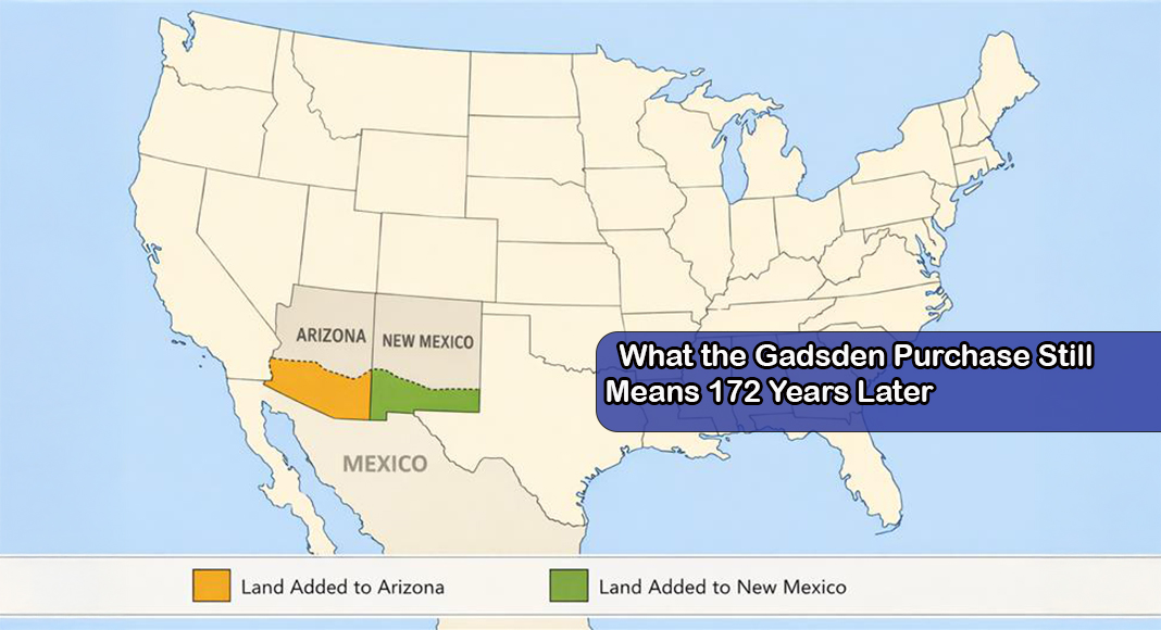
Under the treaty, the United States agreed to pay “$15 million,” a sum that was “later reduced to $10 million,” in exchange for land controlled by Mexico. The agreement transferred “approximately 30,000 square miles of land” to the United States, according to the terms of the treaty.
The land acquired through the Gadsden Purchase now forms part of “southern New Mexico and Arizona.” The territory helped create a more clearly defined border between the two nations and resolved lingering boundary questions following earlier conflicts.

For context, present-day Arizona and New Mexico together cover about 235,580 square miles. This comparison highlights an important point about the Gadsden Purchase. The land transferred in 1853, described in the treaty as “approximately 30,000 square miles,” represented only a portion of what would later become the two states, not the entirety of either one.
Of the approximately 29,640 to 29,670 square miles acquired through the agreement, historians generally agree on an approximate division based on treaty maps and later boundary surveys. About 23,000 to 24,000 square miles were added to what is now southern Arizona, while roughly 5,000 to 6,000 square miles were added to southern New Mexico. This means that nearly four-fifths of the land obtained through the Gadsden Purchase became part of present-day Arizona, with the remaining portion incorporated into New Mexico.
The imbalance reflects both geography and purpose. The largest section of the purchased territory lay south of the Gila River, an area the United States sought for a potential southern railroad route. That corridor ran primarily through present-day Arizona, while New Mexico’s share consisted of smaller border adjustments. Because Arizona did not yet exist as a separate territory in 1853, these figures are historical reconstructions based on later state boundaries rather than measurements used at the time of the treaty. Even so, the estimates are widely accepted by historians and appear consistently in government historical summaries and academic studies.
The treaty was signed “172 years ago,” placing the agreement firmly in the mid-19th century. At the time, both governments chose a negotiated settlement rather than further confrontation. The purchase was formalized through a written treaty, which became known by the name of the U.S. representative who negotiated it, the “Gadsden Purchase.”

The agreement followed “years of conflict between the United States and Mexico,” most notably the Mexican-American War, which ended with Mexico losing “large portions of its territory.” Although the war had concluded, “disagreements over the exact border remained,” and “tensions continued along the frontier,” where both governments faced disputes involving “land boundaries, security, and control of the region.” Rather than risk “further military confrontation,” officials from both countries chose “a negotiated solution.” The Gadsden Purchase allowed the United States to “pay for the land” while enabling Mexico to resolve border issues “through a treaty,” replacing armed conflict with a formal agreement.
The sale is best understood as the result of “ongoing conflicts and political pressure,” not simply personal corruption, although such accusations “have long been part of the story.” After the war, Mexico faced “unresolved border disputes, financial strain, and internal instability.” The government of President Antonio López de Santa Anna agreed to the treaty to “resolve boundary tensions” and “avoid further military conflict.” While Santa Anna was “widely criticized at the time” and later accused by opponents of misusing public funds, “there is no conclusive evidence” that the land sale itself was driven solely by personal enrichment. Most historians cite “geopolitical pressure, security concerns, and Mexico’s weakened position after war” as the primary causes, with corruption claims reflecting “broader mistrust” of Santa Anna’s leadership rather than a proven motive for the treaty.
Today, the effects of the agreement remain visible on maps of the American Southwest. What was described in 1853 as “approximately 30,000 square miles of land” became a permanent part of the United States through a financial payment and a diplomatic agreement that continues to shape the border between the two countries.