


Texas Border Business


By Alex Sosnowski, AccuWeather senior meteorologist
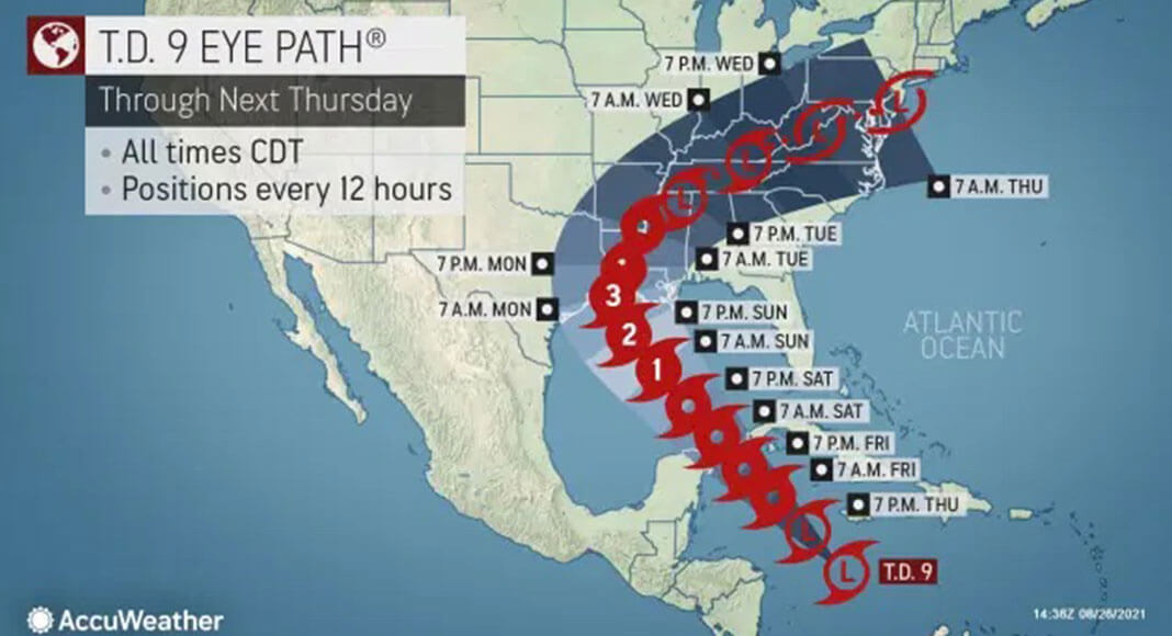
AccuWeather forecasters on Thursday said it was becoming much more likely that parts of the central Gulf Coast would need to prepare for a strike from a major hurricane later Sunday or Monday.
The tropical feature meteorologists have been monitoring was designated Tropical Depression Nine by the National Hurricane Center (NHC) on Thursday, and forecasters said it is becoming increasingly likely that it will eventually strengthen into Tropical Storm Ida, the ninth-named storm of the 2021 Atlantic season.


Tropical Depression Nine was gathering strength over the Caribbean Sea south of Jamaica early Thursday and hurricane hunters from the U.S. Air Force were scheduled to investigate the system. Tropical storm warnings were issued for the Cayman Islands as well as parts of Cuba.
On Thursday morning, the depression was moving to the northwest at a speed of 13 mph and had maximum sustained winds of 35 mph. It was 115 miles south-southwest of Negril, Jamaica, and 210 miles southeast of Grand Cayman Island.
The latest forecast from AccuWeather meteorologists indicates that a scenario in which the depression will continue to increase in strength and take a path into the central Gulf of Mexico is now more likely than had been discussed earlier in the week. The chances for what will likely be Ida to make landfall in southern Mexico were dimming, with a greater focus now being paid to parts of the western Gulf Coast of the United States.
The pace at which the system strengthens will be key in determining the precise direction it ends up taking, AccuWeather Senior Meteorologist Rob Miller said.
“The sooner the system strengthens, the more likely it is to take a northwesterly track into the central Gulf of Mexico, rather than a westward track across Mexico’s Yucatan Peninsula and into the southwestern Gulf,” Miller explained.
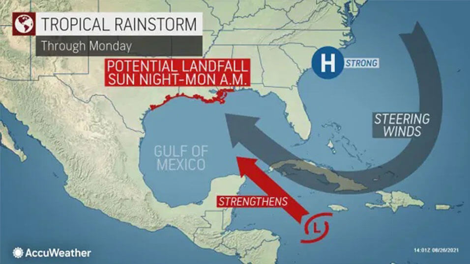
An area of high pressure near the Carolina coast is forecast to weaken just enough to allow the storm to move northwestward into the U.S. The remaining circulation around the high is likely to be enough to keep the storm moving along while over the Caribbean and the Gulf of Mexico.
The storm is projected to slice across the warm waters of the Gulf of Mexico, where rapid intensification is possible, as has been the case with several notorious storms in recent years such as Hurricane Michael in 2018, which struck the Florida Panhandle, and Hurricane Laura in 2020, which slammed southwestern Louisiana. There were a record 11 named storms that struck the U.S. in 2020.
There have been five named systems that have reached land in the U.S. so far this season, but none were hurricanes at the time of landfall.
AccuWeather forecasters are warning residents and businesses from the Texas coast to Louisiana and the panhandles of Mississippi, Alabama and Florida, as well as fishing and petroleum operations, to closely monitor the progress of the developing situation as there may be little time to prepare once the system forms, begins a definitive path and strengthens rapidly along the way.
Rough seas are expected to build outward from the south-central Gulf to the northwest, north-central and northeastern parts of the Gulf Coast and offshore waters beginning on Saturday. Depending on the exact track, size and strength of the storm, conditions may rapidly deteriorate. The first rain bands may arrive along portions of the central Gulf coast as early as Saturday night or Sunday.
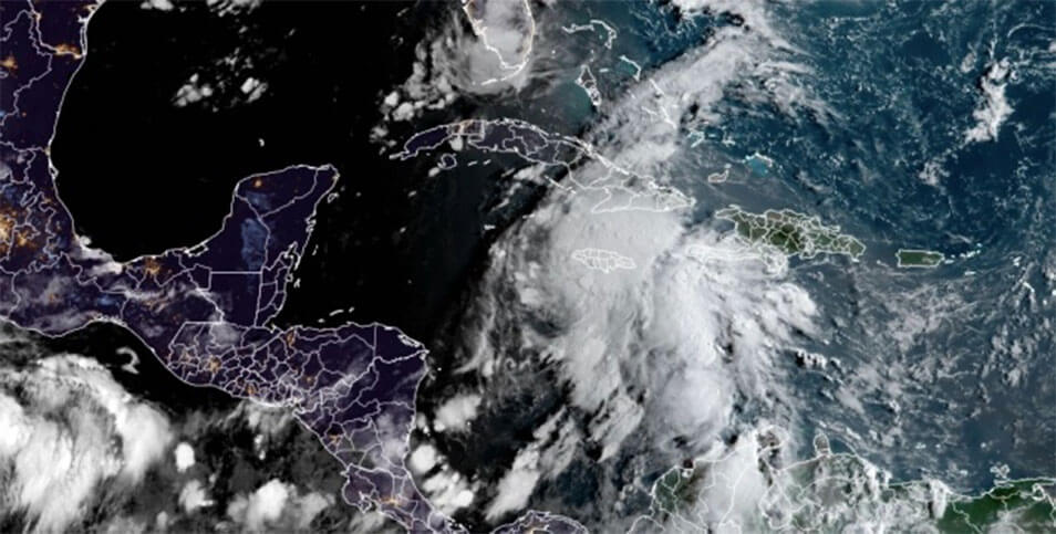
The system of interest was a broad area of showers and thunderstorms south of Cuba as of early Thursday morning. However, satellite images revealed a steady uptick in showers and thunderstorms over the Caribbean since the start of this week, and the system was upgraded to Tropical Depression Nine at around midday on Thursday. Wind shear and dry air on one side of the system had been inhibiting development into early Thursday, but that was beginning to change, forecasters said.
“The atmospheric environment is expected to rapidly become more conducive for this system to organize and strengthen,” AccuWeather Senior Meteorologist Rob Miller said.
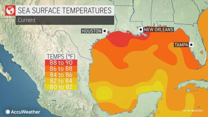
Sea-surface temperatures in the Gulf of Mexico could aid a strengthening storm, as they are well into the mid-80s in many areas, which is significantly above normal for this time of year.
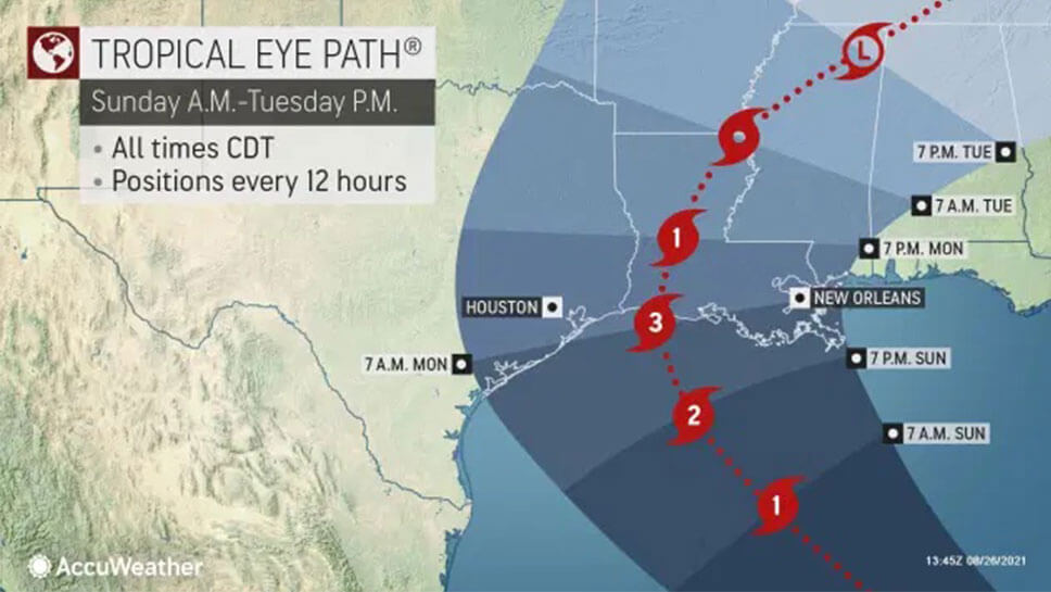
“Unfortunately, it just seems like it’s making a beeline toward the Louisiana coast,” AccuWeather Chief Broadcast Meteorologist Bernie Rayno said, cautioning that the system hadn’t formed yet early on Thursday so the path wasn’t a certainty.
The precise location of where the center manages to form may determine whether or not the system remains over open water between Mexico’s Yucatan Peninsula and the western tip of Cuba, or if the center of the system scrapes land in either of the two areas.
Water temperatures are in the middle to upper 80s F in the Yucatan Channel. Interaction with either land area may temporarily slow the strengthening process somewhat, while a slip through the channel may allow steady strengthening
Regardless, a path into the central Gulf of Mexico north of the Yucatan Peninsula and western Cuba is anticipated by the end of this week. While in the Gulf of Mexico this weekend, additional quick strengthening is likely with the potential for the system to become not only a hurricane but perhaps the second major hurricane, which is Category 3 or higher on the Saffir-Simpson Hurricane Scale, of the Atlantic season. A major hurricane has maximum sustained winds of 111 mph or greater. Thus far, Grace has been the only hurricane to reach Category 3 force, with maximum sustained winds of 125 mph just prior to striking Mexico for a second time on Aug. 21.
Once a center forms and begins to track, forecasters will be able to see a clearer picture of where the system will make landfall along the U.S. Gulf coast and whether the timing of landfall will be later Sunday or in the early hours on Monday.
“Near where the center of the storm moves ashore, wind gusts of 115-120 mph are possible and an AccuWeather Local StormMax™ of 130 mph is anticipated,” AccuWeather Meteorologist Randy Adkins said.
In terms of rainfall, a general 4-8 inches is forecast along the path of the storm nearest the Gulf coast with locally higher amounts — if the storm maintains a steady forward speed. Should the storm’s progress slow down over the southern U.S., much heavier rainfall is possible.
Louisiana, which may end up in the crosshairs of the latest budding tropical system, was heavily targeted by direct strikes during the record 2020 Atlantic hurricane season. Tropical Storm Cristobal, Category 4 Hurricane Laura, Category 2 Hurricane Delta and Category 3 Hurricane Zeta all made landfall in the state, but Hurricane Marco had weakened to below tropical depression status prior to moving ashore.
Through late August, four tropical storms — Danny, Elsa, Fred, and Henri — have made landfall on U.S. soil. And back in early June, Tropical Storm Claudette impacted the U.S., but in an unusual meteorological twist, it was named a tropical storm by the NHC while it was over Louisiana, so it never made a traditional landfall.